Council on Energy, Environment and Water Integrated | International | Independent
TMC and CEEW. 2024. Thane City Action Plan for Flood Risk Management 2024. Thane: Thane Municipal Corporation; and New Delhi: Council on Energy, Environment and Water (CEEW).
This report presents a first-of-its-kind of action plan for flood risk management in Thane City. The plan offers a framework for city administrators to prepare for and respond to urban floods and mitigate the associated risks. For achieving this, it provides actionable and holistic recommendations for strengthening the adaptive capacity of the city, which would help transform Thane into a flood-resilient smart city.
The plan is prepared following the sequential steps. First, an analysis of historical rainfall data of 52 years was performed to prepare the intensity-duration-frequency (IDF) curve. Second, the peak flow discharge was estimated for different return periods. Third, the administrative ward–wise urban flood risk index was developed and computed to assess the extent of relative flood risk. Fourth, flood hotspots were identified for the administrative ward at very high and high risk. Fifth, a set of actionable short, medium, and long-term recommendations for monsoon and non-monsoon phases were made.
Urban centres worldwide are experiencing a common trend of increasing concentration of population and economic activities but are inadequately prepared in terms of planning. It is expected that 70 per cent of the global population will live in urban areas by 2050 (Ferguson et al. 2023, IPCC n.d). Further, unplanned development in urban centres increase the risk of climate change-induced disasters such as storms and floods. These will increase the exposure and vulnerability of the urban population and infrastructure. Approximately 1.54 billion people, or 20 per cent of the world’s population, are directly exposed to substantial flood risk (Rentschler, Salhab, and Jafino 2022).
India has 5,052 urban local bodies (ULBs) (MoHUA 2015), which represent more than 31 per cent of the country’s total population. As is the case with cities and metropolitan areas worldwide, urban areas in India face multifaceted challenges that are becoming complex due to climate-driven changes. One such challenge is the increasing frequency of high-intensity rainfall events. These extreme climate events that occur over a very short time significantly impact the existing adaptive capacity of governments and communities. Vulnerable population, especially senior citizens, children, and persons with disabilities, are impacted the most. Such social repercussions escalate the risks associated with urban flooding.
With the number and intensity of instances of urban flooding increasing due to climate change, cities must take action to protect vulnerable communities by mitigating floods and maintaining and restoring existing ageing urban flood control infrastructure. To adopt a proactive and holistic approach to urban flooding, cities must first conduct a flood risk assessment as recommended by the National Disaster Management Plan (NDMP), 2019. This assessment should focus on hazard, exposure, and vulnerability, followed by the development of effective mitigation, preparedness, and response mechanisms as outlined in the NDMP (NDMA 2019) and the World Bank’s Urban Flood Risk Handbook (Ferguson et al. 2023).
Coastal cities are most impacted by sudden and extreme storms and floods. For instance, Thane, in Maharashtra, witnesses floods on a recurrent basis. Thane City is situated between east longitude 72.50° and north latitude 19.10°, covers an area of approximately 128 sq km, and is subdivided into 9 Prabhag Samitees (PS) (administrative wards) and 33 electoral wards.
CEEW and the administration of Thane City collaborated to address the challenges posed by urban floods by developing a city-level flood action plan. This report presents an analysis of historical rainfall data that was used to prepare the intensity-duration-frequency (IDF) curve and estimate the peak flow discharge. It further identifies the hydrological, governance, social, and economic factors at the ward committee/Prabhag Samitee level that can influence the risks posed by urban floods; maps urban flood hotspots; and suggests recommendations to prepare and respond to flood events (Figure ES1).
Figure ES1 Key aspects of urban flood risk action plan for Thane Municipal Corporation
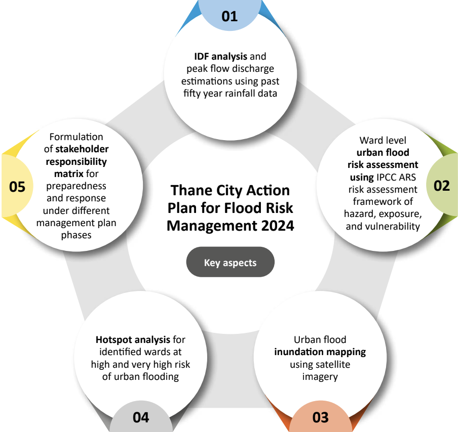
Source: Authors’ compilation
Thane City’s Action Plan for Flood Risk Management (APFRM) comprises three specific components: why take action, where to prioritise, and who will take action.
Why take action: This section involves tracing rainfall trends using historical rainfall data (1970–2021) and preparing the IDF curve. The 24-hour maximum precipitation over the last 52 years ranged from 72 mm to 267 mm, representing a high temporal variability; the coefficient of variation was 32 per cent. Such a high variation in precipitation presents a challenge to the city administration, especially during years with high rainfall that can potentially cause urban flooding. In the last 52 years (1970–2021), the peak flow discharge for a return period of two years was 16.77 cubic metres per second (cumecs) per sq km, and for a ten-year return period, it was 17.13 cumecs per sq km (Figure ES2). However, the current carrying capacity of the drainage system in Thane is just 16.73 cumecs per square km, indicating that the city is not equipped to manage a rainfall event with a return period of ten years. Hence, there is a need to upgrade the existing stormwater drainage network both in terms of constructing a new network and maintaining existing infrastructure. The Thane Municipal Corporation (TMC) already has plans to upgrade its stormwater network by adding 131 km as part of a new drainage network under its Integrated Nullah Development Programme (INDP); the city needs to ensure that its capacity is sufficient to handle the rainfall event that happens every ten years.
Figure ES2: Peak flow discharge estimation for areas under Thane Municipal Corporation for different scenarios
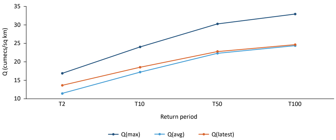
Source: Authors’ analysis using IMD rainfall data; Q(max) refer to the period of 2002-2006, when the maximum discharge was observed and the Q(latest) peek discharge refer to the period of 2017-2021
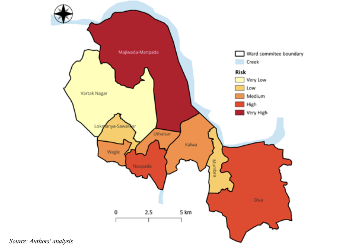
Where to prioritise action: According to Thane city's urban flood risk index (Figure ES3), the Majiwada-Manpada administrative block is at very high risk, followed by the Diva and Naupada blocks, which fall in the high-risk category. They are followed by Kalwa, Wagle, and Uthalsar blocks, which show moderate risk. The Lokmanya-Sawarkar Nagar and Mumbra blocks fall in the low-risk category, followed by the Vartak Nagar block, which has a very low risk. The risk analysis will help decision-makers prioritise interventions and identify relevant stakeholders and the type of interventions needed in each administrative block.
Figure ES3: Urban flood risk index for Thane City across different Prabhag Samitees
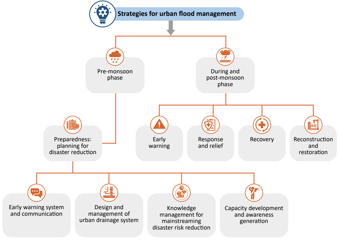
Who will (and how to) take action: Stakeholders’ engagement is central to validating the urban flood risk assessment findings and ensuring uptake and efficient coordination and implementation of the plan. The APFRM provides a set of actionable recommendations for the TMC, which, once implemented, would play a pivotal role in strategising urban flood risk management and adaptation at the administrative level. The plan has adopted a phased approach consisting of the pre-monsoon (December-May), monsoon (June-September), and post-monsoon (October-November) phases (see Figure ES4). The pre-monsoon phase is considered the preparedness period, for which short-, medium-, and long-term recommendations have been provided. The hub-spoke model is followed for the recommendations for the monsoon and post-monsoon phases. As per this approach, an Emergency operation centre (EOC) will coordinate the activities of each relevant department of the TMC. The responsibility of each department during this phase is divided into four major heads: early warning, response and relief, recovery, and reconstruction and restoration.
Figure ES4: An effective urban flood management underlines the importance of phase-wise strategies
Source: Authors’ compilation
CEEW analysis suggests that 57 per cent of Indian districts are vulnerable to extreme flooding events and their compounding effect. Flooding, particularly in urban areas, can make critical public infrastructure such as hospitals, education centres, transportation facilities, etc., inaccessible. Further it can disrupt the supply of basic and essential services, including electricity and water. Therefore, strong action for flood management in urban areas is a desirable goal.
In recent years, Indian cities have witnessed a rising trend of urban flooding. Some of the most notable among them were the floods in Chennai in November 2021, Bengaluru and Ahmedabad in 2022, parts of Delhi in July 2023, and Nagpur in September 2023. The major reasons behind the rising urban flood risk are the combination of climate change driven impact on precipitation patterns and rapid and unplanned urbanisation. On one hand, climate change-induced intensified precipitation is leading to more frequent and heavy downpours that overwhelm the drainage system in many cities. On the other hand, insufficient drainage systems in the growing urban spaces are exacerbating flooding during storm events due to the additional runoff from built-up areas.
It is imperative to formulate local-level action plans to prepare for and respond to urban floods, and mitigate long-term risk. Drawing inspiration from the risk-based approach of the Thane City Action Plan for Flood Risk Management 2024 and aligning with the principles outlined in the National Disaster Management Plan, municipal authorities should formulate similar flood action plans tailored to their respective cities. Such plans should provide quick, actionable and holistic recommendations for strengthening the adaptive capacity of the city, thereby aiding in effective management of urban floods.
Yes, Thane is prone to urban flooding. Being a coastal city, Thane receives an average annual rainfall of 2932 mm with high inter-annual variability. As per CEEW analysis, between 1970 and 2021, the maximum daily rainfall varied from 72 millimetres (mm) to 267 mm, leading to extreme rainfall events during the wet years. This is further exacerbated by high urbanisation and inadequate drainage design that result in poor management of stormwater.
Enabling Circular Economy in Used Water Management in India

Policy Study on Re-calibrating Institutions for Climate Action
Water Balance and Benefit Sharing Approach to Reduce Water Deficit in an Indian River Basin
Toolkit for "Preparing City Action Plans for Reuse of Treated Used Water"
Evaluating Policy Coherence in Food, Land, and Water SystemsEvidence from India
